Road Trip on the Golan - From Banias to Orach Junction
Highway 98 is Israel's eastern road. Previously, this road was accessible only to heavy military vehicles, and it became possible to travel on it with a private or rented car only 30 years later. Hermon's snow-capped peaks, Druze villages with their traditions, flourishing Israeli settlements, and stunning nature are what you can experience on Route 98.
- Vehicle Type: Standard Car
- Location: Banias Reserve and Surroundings
- Route Length: Approximately 70 km
- Duration: 2 - 4 hours
- Starting Point: Junction of Highway 99 and 989
- Endpoint: Orach Junction
- Difficulty: Easy
- Season: Spring, Summer, Autumn, Winter

Journey Start
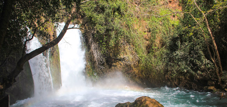
From Kiryat Shmona, turn right at Zion Junction and follow Route 99. After about one and a half minutes, turn right to the Banias Waterfalls. The path passes through beautiful orchards and fig trees, and by Druze tents selling fruits from the Golan Heights. After a few hundred meters, the road makes a sharp left turn, leads into the Banias Reservoir (on the left side), and reaches the junction. This is our starting point (1).
Nimrod Fortress
At the junction (1), turn left onto Road 989 and drive uphill, where a magnificent view awaits. On the left, you can see the Hula Valley, the city of Kiryat Shmona, and the Nimrod Fortress. After about four kilometers, the road turns east, and on the left, you will see the entrance gate to the Nimrod National Park (2). The fortress held a strategically important position and controlled the road to Damascus. Throughout history, the fortress changed hands multiple times and survived seven major battles.
From Majdal Shams
After another kilometer, on the left, you will find a beautiful oak grove with a sacred site called Makam Nabi al-Zuhri. Near the road, there is a monument to fallen soldiers of the intelligence unit of the "Egoz" brigade. Later, you will pass the gates of Moshav Neve Ativ, founded by soldiers of the Egoz Patrol. Another kilometer ahead, you will reach the junction and see the entrance to the large Druze village of Majdal Shams. Turn right onto Road 98, drive through the gas station, and reach the center of the village (3).
The Hill of Screams
Those wishing to visit Mount Hermon should turn left and continue climbing the snow-capped mountain. To continue the journey, turn right and drive a few hundred meters down the road to the monument of Sultan al-Atrash, the leader of the Druze revolt in the 1920s in Lebanon and a national hero of the community. Sultan, riding his noble steed, symbolizes the pride of the Druze.
We now drive along a beautiful green road between plum and apple orchards. At the northeastern edge of the village, the road turns south, and in front of you is a relatively high hill – the Hill of Screams. East of the hill lies the border between Israel and Syria (4). Large Druze clans live here. You can relax and refresh yourself in a Druze restaurant called A-Tina, enjoying a delicious lunch.
Neve Yafuri
After about 2.5 kilometers, the road passes Neve Yafuri, one of the holiest tombs of the Druze. The Prophet Yafuri is considered the reincarnation of the moral man al-Gafari, a companion of the Prophet Muhammad. On Saturdays, families of the community gather here. At the market, you can buy very tasty fruits, honey, and olive oil.
Ram Pool
After about half a kilometer, a country road leads to the Ram Pool (5). It is a natural reservoir, a great spot for a picnic and fishing. In ancient times, people tried to solve the mystery of its formation. Today, it is believed that hidden springs along with melted water from Mount Hermon feed the pool. Another theory suggests it is the crater of an ancient volcano or a space formed by the melting of chalk rocks. Many legends are associated with this mysterious pool.
Restaurant Food Court
The road leaves the parking lot of a large pool, crosses a narrow bridge over the Nahal Saar, and connects with Highway 98 descending from Mount Hermon. Turn left, and after a kilometer, you will reach the Restaurant Food Court. Here, you will find several popular restaurants preparing delicious falafel and honey-soaked baklava. Turn left onto Route 98 and leave the town.
Valley of Tears
After about 800 meters, you reach the Jaara-Odem junction. After about four kilometers, you arrive at Moshav Odem. From the Highway 98 junction, continue southward. The road passes a series of wind turbines and offers spectacular views. Across the valley, Syrian forces attempted to advance toward Quneitra. A damaged Syrian tank stands as a reminder of the battle.
Mount Bental
The road continues to the mountain ridges and outposts until we reach the Bar-On junction. The mountain south of the junction is Mount Bental. To climb it, turn right onto Road 959 and follow the signs to Merom Golan. This kibbutz was established a month after the 1967 conquest. From the top, you can enjoy breathtaking views of the region. The summit atmosphere can be experienced with a cup of espresso at the "Kofi Anan" café.
Highway 98
Leave the area and follow Highway 98 southward. The road offers spectacular views and leads through significant historical and scenic spots that define the Golan region.


